


Impact of Typhoon "Mangkhut" on the Facade of Buildings in Hong Kong, Shenzhen and Guangdong (2) -- Whether Curtain Wall for Buildings Can Resist Typhoon "Mangkhut"


Typhoon Mangkhut roared in and left, leaving behind a mess and doubts. Curtain walls, doors and windows in the affected areas were damaged to varying degrees. Whether the causes of these problems are natural disasters or man-made disasters, whether the wind speed of "Mangkhut" typhoon exceeds the maximum wind speed of 50 years used in the curtain wall design, and whether the building owners can find the answer to how many levels of typhoons their curtain walls can withstand. We calculate the relationship between the design value and the typhoon wind speed from the basic wind pressure of each region, calculate whether the wind pressure resistance design required by the specification can resist the attack of "Mangkhut", and calculate the basic wind speed and the typhoon level that can be withstood in each region.
◆ Basic wind pressure and wind speed:
The basic wind pressure in the Load Code for the Design of Building Structures (GB 50009 2012) is interpreted as the reference pressure of wind load. Generally, the wind speed determined by the maximum value of 50 year return period is obtained through probability statistics based on the 10 min average wind speed observation data at 10m height on the open and flat ground, and then the corresponding density of air is considered, and the wind pressure is determined according to the Bernoulli formula. The wind speed corresponding to the basic wind pressure of Hong Kong, Shenzhen and Guangzhou calculated according to Bernoulli formula is as follows:
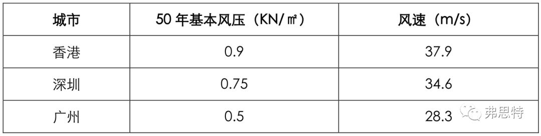
Note: Bernoulli formula-basic wind pressure (ω0) = 1/2 * air density (ρ) * wind speed² (υ0²)
◆ Calculation of wind speed at different time intervals:
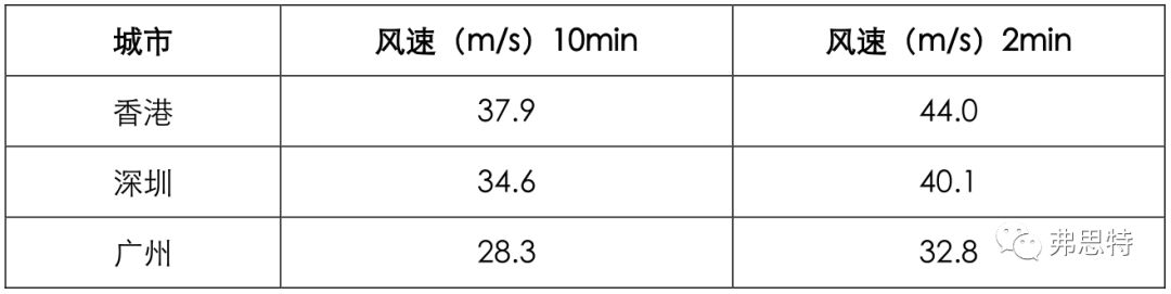
The basic wind pressure is the average wind speed observed in 10 minutes at the height of 10m on the local open and flat ground, that is, the average wind speed in 10 minutes at the height of 10m when the ground roughness is Class B. The wind speed in the meteorological report is the wind speed with a time interval of two minutes. Therefore, we calculate the wind speed with a time interval of two minutes in Hong Kong, Shenzhen and Guangzhou according to the "average ratio of wind speeds with different time intervals and 10 minutes" (as shown in the figure below) as follows:
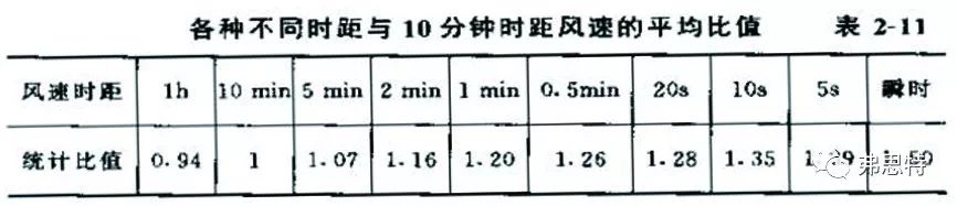
Pictures taken from: Zhang Xiangting, Handbook of Wind Load Theory and Wind Resistance Calculation for Engineering Structures
◆ Comparison between standard design value and "Mangkhut" wind speed:
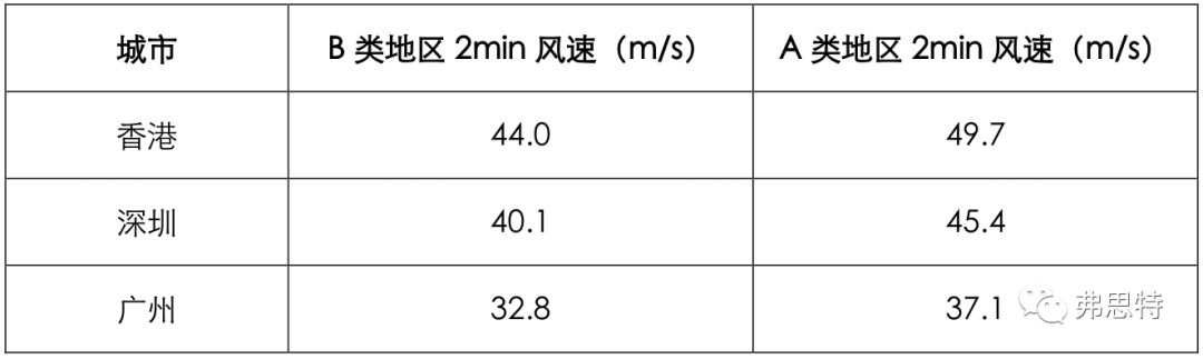
The typhoon is the wind blowing from the sea to the land, and the site roughness is equivalent to the landform of Class A in the load specification. According to the Load Code for the Design of Building Structures (GB 50009 2012), the height variation coefficient of wind pressure at 10m in Class A area is 1.28, and that in Class B area is 1.0, that is, ω0a = 1.28ω0B,
which is substituted into the Bernoulli formula: 1/2*ρ*υ0 A²=1.28*1/2*ρ*υ0 B².
It is concluded that υ0A²=1.28*υ0B², and finally the ratio coefficient of basic wind speed of Class A and Class B landforms is υ0 A/υ 0B=1.28^0.5=1.13, and then the wind speed is converted into the wind speed of Class A area as follows:
The maximum wind speed at the center of "Mangkhut" landing is 45m/s, which is less than the maximum wind speed in Hong Kong and Shenzhen. In addition, according to the typhoon track map, the maximum wind speed in Guangzhou is 24.5-28.4m/s, which is less than the maximum bearable wind speed in Guangzhou. To sum up, the standard design value can meet the requirements of "Mangkhut". The typhoon radius chart is as follows:
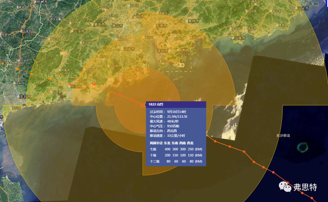
Pictures taken from the National Meteorological Center of CMA ·Typhoon Network
◆ Standard design value and actual measurement value of "Mangkhut" wind speed:
According to the data released by the network, the maximum wind speed measured on land in Guangzhou is 37.3m/s, that in Shenzhen is 52.7m/s, and that in Hong Kong is about 48.6m/s. In the design of the bearing capacity of curtain wall components, the wind load will be multiplied by a partial coefficient of 1.4. According to the derivation method mentioned above, the design value of wind speed will be amplified by about 18%, and the calculation is as follows:
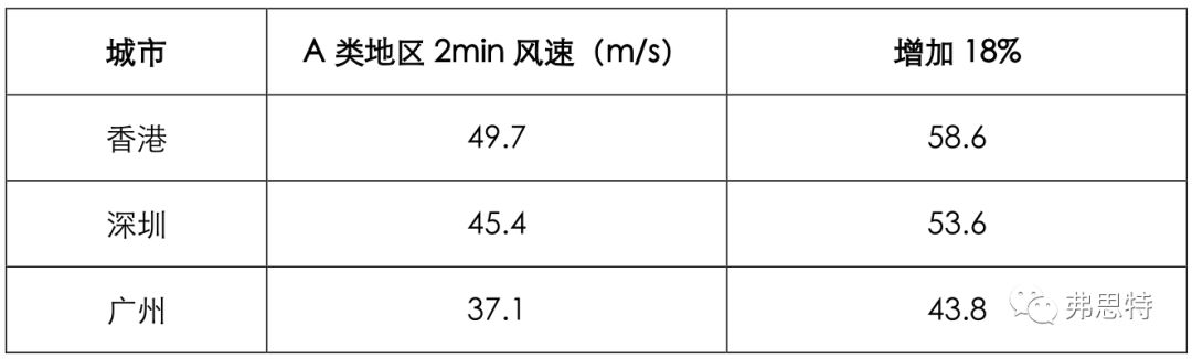
After considering the design amplification value, the design values of the three specifications can resist the maximum wind speed of "Mangkhut" typhoon.
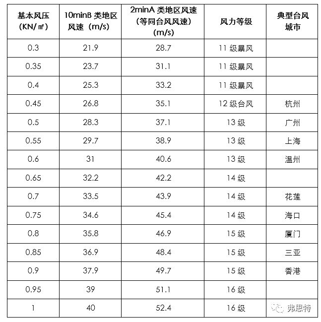
◆ Comparison table of basic wind pressure and bearable typhoon wind speed
The level of basic wind pressure used in the design of buildings in each region will allow the buildings in that region to withstand the typhoon level corresponding to that wind pressure. By using the above calculation method, the basic wind pressure of each place is converted into the maximum wind speed when the typhoon lands, and then the typhoon grade that the buildings in the area can resist can be known.
Typhoon resistance rating of buildings
It is worth noting that when the wind speed exceeds the wind speed level listed in the table, the building will not necessarily be damaged. It can be seen from the table "average ratio of wind speed of different time intervals to that of 10 min" that the instantaneous wind speed is larger than that of 2 min, so the instantaneous wind speed that the building can resist is higher than the level in the table. In addition, during the visit, it was found that many damages were caused by negative wind pressure. In the process of curtain wall design, attention should be paid to the selection of relevant materials and structural checking under negative wind pressure.
Reference:
GB50009-2012 Load Code for the Design of Building Structures
Zhang Xiangting's Handbook of Wind Load Theory and Wind Resistance Calculation for Engineering Structures